|
|||
|
Flytomap is a valid and interesting alternative, Benetti Yachts Top Ten summer 2011,2012,2013,2014,2015 & 2016 Featured in : On the Deck ▶ Gargano coverage resident in the app. It works WITHOUT mobile coverage! ▶ Worldwide Marine Maps available when connected, thanks to viewer.flytomap.com ▶ Worldwide Satellite image overlay on charts ▶ Worldwide Terrain feature overlay on charts, thanks to Open Street Map, Open Cycle Map, Bing,Earth,GMap ▶ Worldwide Weather forecast ▶ Use to Explore: √ Latitude and Longitude to go to your favorite places √ Search your Favorite points directly √ Zoom, Rotate and Pan ealisy just by a finger touch √Quick Object information by tapping on the item, thanks to vector technology √ GPS Heading Vector towards the direction movement √ Distance measurement tool to easily calculate the distance from one location to another √ Route planning, Waypoints - Insert the target/destination and see in real time your speed, distance and bearing √ Magnifying Lens for all info √ Unlimited Tracks, Markers, Geo-tagged photos, records. Share via email and view on Google, Flytomap Viewer, KMZ format √ Select Depth Contours √ a la carte menu √ And so much more to come - It’s the only app you will ever need! Our charts are installed on: GARMIN NAVICO LOWRANCE B&G NORTHSTAR EAGLE SIMRAD Learn more about Flytomap : www.flytomap.com and join us on Facebook or Twitter. Flytomap is committed to constant improvement. We listen to our users and systematically add the most requested features. Thank you for your feedback! "Continued use of GPS running in the background can dramatically decrease battery life." © ©2008-2019 FlyToMap |
You are here: Home // ナビゲーション // Marine : Gargano – GPS map offline chart Navigator – Flytomap
Marine : Gargano – GPS map offline chart Navigator – Flytomap
2月 04, 2019 | コメントは受け付けていません。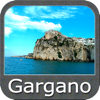
Tags: Navigation